

“You Are Here.”
MBTA (Massachusetts Bay Transportation Authority) Wayfinding Signage Project
DURATION
TYPE
TEAM
CAPACITY
2022. 10 - 2022. 12. (10 weeks)
Physical Space UX Project
Sohee Kang, Lindsey Petchel, Disha Rathod
UX Researcher & Graphic Designer
SCHOOL PROJECT
OVERVIEW
The MBTA, the Massachusetts Bay Transportation Authority, is the public transportation system in the Boston area. It is the oldest public transportation in the United States, and many tourists and commuters rely on the MBTA. However, despite the city’s being full of tourists, students, and office workers, the experience of using the MBTA was not pleasant compared to other big cities. This project was started to find out the cause of the low-quality experience of the MBTA riders, identify riders’ behavior and context, and provide design solutions so that people's journeys can be enjoyable.
FINAL DESIGN
-
![]()
Track Directory & Floor Signage
Park Street station has a complex lane and platform system, and through our observation people who weren’t familiar with the station found it hard to find the right platform and exit. Therefore, having a prominent track directory and clear floor signage will help people find their way.
-
![]()
Column Location Maps
We multiplied existing signage and added progress signage on columns to help people get the info they need.
-
![]()
Extended Floor Signage on Thresholds
Our floor signage extends to the thresholds which will help people could find their way easily.
-
![]()
Revised Station Directory
Station Directory will help people understand where they are and where they should go. Also, in our design, we decided to use more matte material to reduce light reflection.
-
![Column Line Signage]()
Column Line Signage
Park Street station has many pillars that block people’s sight. After several iterations, we decided to use the pillars as an identifier for the platform. Also, a route map was attached to the side so that people could easily know their route.
-
![]()
Exterior Signage
Illuminated signage and triangular prism shapes will help people find the entrance from a distance.
-
![]()
Floor Signages
They will lead the rider to the right place, and they will be made using durable anti-skid material.
-
![]()
Stair Signage
Having this anti-skid signage on stairs will guide people to find their way easily. Also, we tried to get rid of excessive wall color to avoid distraction.


DESIGN APPROACH
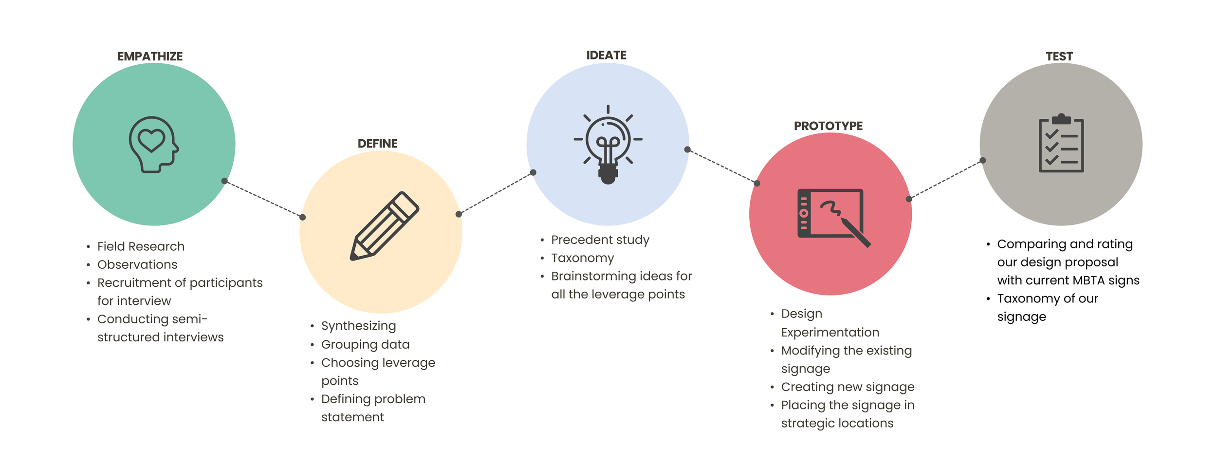
FIELD RESEARCH
01. EMPATHIZE
Our team observed people using the MBTA system for weeks and visited 10+ stations.
We observed that people find it hard to find their way inside complex transfer stations and some information is disconnected.
After much field research, we decided to use the Park Street station as an example to present our new wayfinding signage design. This is because Park Street station is located in the center of Boston, and is a busy transit station used by both commuters and visitors.


Insights from Field Research
INTERVIEW
Interview Process
Interview Brief

Findings & Insights from Interviews


GOAL
FORMAT
PARTICIPANTS
PERIOD
DURATION
To see people’s thoughts about the overall MBTA system and find out some problems that we can tackle
Semi-structured Interview
9 participants (4 Visitors & 5 Commuters)
Oct 02 - Oct 08, 2022
50 - 60 mins
SYNTHESIZING
02. DEFINE
Based on the research findings, our team could find three barriers; Payment, Incorrect real-time info, and Identifying location. We brainstormed concepts for each barrier, and we decided our concept to “You Are Here.“


“You Are Here”
How do you know where you are?
Touchpoints of information to ensure the rider knows where they are located within the MBTA system
Reinforcement of existing signage within the MBTA system, to show users where the information exists and how they access it
Defined locations of amenities and location tools to reduce time looking around and searching
SURVEY

With the concept we decided on, we conducted a survey to find out the problems with the current signage. The survey surveyed people's thoughts on the sign of MBTA through interview participants and 6 other MBTA users, a total of 15 people.
Through the survey results, we found that most MBTA riders…
Want to know transfer-related information
Find it hard to know where they are
Think the current signage is difficult to see due to problems such as size/position
Are satisfied with the current use of color in MBTA.
PROBLEM STATEMENT
“ How can we improve wayfinding methods at MBTA stations for location context and transfers? ”
SCENARIOS
We developed three scenarios based on our previous research (interviews, field research, and survey) to address the MBTA rider’s pain points and find out potential touchpoints.

PRECEDENT STUDY
03. IDEATE


Before developing our idea, we studied precedents. Precedents were mainly other public transportation systems and complex multi-story buildings. Our group decided to use 9 indicators (Visibility, Readability, Scale/Size, Use of color, Effectiveness, Font, Use of words, Lack of clutter, and Materiality) to evaluate each precedent.
Based on the precedent study, our team designed new signage related to wayfinding, discussed our drafts, and integrated our ideas.
Inspiration & Sketch
DESIGN EXPERIMENTS
04. PROTOTYPE

Based on the sketch, our team designed signages related to wayfinding and discussed new signage, and integrated our designs. For example, as shown in the figure on the right, pillars located inside the station were redesigned to be used for delivering line information. However, this design was discarded as the branch alphabet (D in the picture. Boston’s Green Line has B, C, D, and E branches.) was displayed at the bottom, so it could not be seen when there are many people.
COMPARISON
05. TEST

After deciding on the final designs, our group decided to compare them with the current signage in the Park Street station. Among 9 indicators previously used, we picked Visibility, Readability, and Scale/Size for agile evaluation.
Although most of the newer signage has improved compared to the previous ones, there are still some that are considered to be lacking. If we were given the opportunity, we should think of a design that recreates the space anew, rather than modifying it based on the existing design.
NEXT STEPS

Axon by Lindsey Petchel